Vous êtes ici : Accueil / L’itinéraire
Vous êtes ici : Accueil / L’itinéraire
On distingue deux types de base de lancement de bombe volante V1 : les sites « premier type » (parfois qualifiés de sites dits « lourds ») et les sites « modifiés » aussi appelés sites « légers », ces derniers se distinguent par une simplification progressive de l’agencement de la base avec notamment une réduction du nombre de structures fixes.
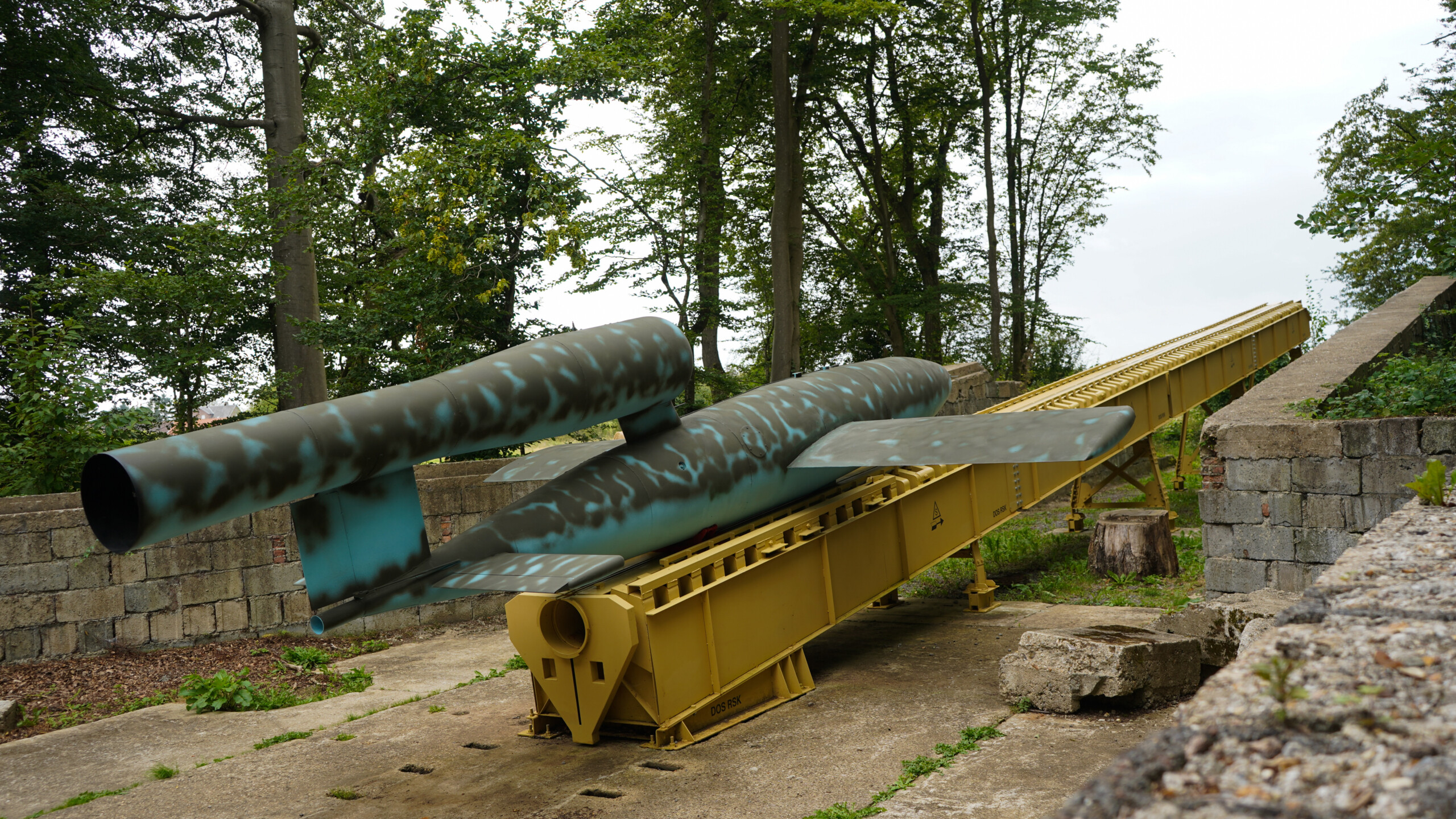
Les chantiers des sites « premier type » sont entamés durant l’été 1943. Chaque base comprend douze ouvrages, ils sont nécessaires aux différentes étapes de la préparation de l’arme. Ces structures sont reliées les unes aux autres par un vaste réseau de pistes bétonnées. Les sites sont implantés dans des zones offrant des possibilités de camouflage, souvent dans les bois, parfois dans des cours de châteaux ou de fermes. Néanmoins, du fait de leur aspect caractéristique, ces bases sont rapidement repérées par l’aviation anglaise et subissent d’intenses bombardements, souvent avant même que la construction ne soit achevée.
À l’hiver 1944, les Allemands entreprennent la construction du second type de site : les sites « modifiés ». La structure des bases est simplifiée, le nombre de bâtiments est réduit, ne sont conservés que les édifices indispensables dans le processus de préparation du V1 (notamment la rampe de lancement et la plateforme amagnétique). Ces modifications répondent à des impératifs techniques : simplifier l’agencement du site permet de diminuer les coûts de construction (la quantité de béton requise étant moindre) et d’accélérer le processus de mise en service de la base. Les sites « modifiés » présentent également l’avantage de se fondre dans le paysage plus facilement, car nettement moins imposants. Ils comprennent au maximum six bâtiments, dont seulement trois sont entièrement bétonnés. À la différence des sites « premier type », aucun V1 n’est directement stocké sur les bases dites « modifiées », on parle d’une alimentation en « flux tendu ».
Certains sites de l’itinéraire de randonnée historique et de mémoire se trouvent sur des domaines privés, l’entrée peut y être interdite.

On distingue deux types de base de lancement de bombe volante V1 : les sites « premier type » (parfois qualifiés de sites dits « lourds ») et les sites « modifiés » aussi appelés sites « légers », ces derniers se distinguent par une simplification progressive de l’agencement de la base avec notamment une réduction du nombre de structures fixes.
Les chantiers des sites « premier type » sont entamés durant l’été 1943. Chaque base comprend douze ouvrages, ils sont nécessaires aux différentes étapes de la préparation de l’arme. Ces structures sont reliées les unes aux autres par un vaste réseau de pistes bétonnées. Les sites sont implantés dans des zones offrant des possibilités de camouflage, souvent dans les bois, parfois dans des cours de châteaux ou de fermes. Néanmoins, du fait de leur aspect caractéristique, ces bases sont rapidement repérées par l’aviation anglaise et subissent d’intenses bombardements, souvent avant même que la construction ne soit achevée.
À l’hiver 1944, les Allemands entreprennent la construction du second type de site : les sites « modifiés ». La structure des bases est simplifiée, le nombre de bâtiments est réduit, ne sont conservés que les édifices indispensables dans le processus de préparation du V1 (notamment la rampe de lancement et la plateforme amagnétique). Ces modifications répondent à des impératifs techniques : simplifier l’agencement du site permet de diminuer les coûts de construction (la quantité de béton requise étant moindre) et d’accélérer le processus de mise en service de la base. Les sites « modifiés » présentent également l’avantage de se fondre dans le paysage plus facilement, car nettement moins imposants. Ils comprennent au maximum six bâtiments, dont seulement trois sont entièrement bétonnés. À la différence des sites « premier type », aucun V1 n’est directement stocké sur les bases dites « modifiées », on parle d’une alimentation en « flux tendu ».
Certains sites de l’itinéraire de randonnée historique et de mémoire se trouvent sur des domaines privés, l’entrée peut y être interdite.
Guerville – Poteau de Montauban – Site Nr 161
Campneuseville – Beaulieu – Site Nr 671
Saint-Riquier-en-Rivière – Poteau Maître Jean
Saint-Léger-aux-Bois – Le Mesnil Allard – Site Nr 673
Saint-Léger-aux-Bois – Les Sapins
Rieux – Val de l’eau – Site Nr 163
Richemont – Les Cateliers – Site Nr 183
Richemont – Le transformateur – Site Nr 182
Rétonval – La Ventillette – Site XXX
Rétonval – Le Mont Gournoy – Site Nr 187
Rétonval – Le bout du haut – Site Nr 188
Réalcamp – Les hauts buissons – Site Nr 170
Réalcamp – Les Essartis – Site Nr 169
Réalcamp – Le grand marché – Site Nr 180
Les Landes – Piste 60 – Site Nr 189
Campneuseville – La Houssaye – Site Nr 179
Campneuseville – Bérémont – Site Nr 171
Aumale – Bois de la Vierge – Nr 192
Aubéguimont – Coquereaux – Nr 184

2025 © L’Itinéraire V1 en vallées de la Bresle et de l’Yères | Conception & Réalisation : Le Plus Du Web